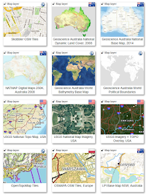
If you publish or know of any interesting web services with base maps, satellite/aerial imagery or thematic overlays you can be a part of this project by submitting a list of your favourite web services as a response to this post.
You can also help fund the initiative by signing up as a MapDeck user and creating catalogue entries yourself after purchasing the Map Layers Manager tool!
The objective is to create a human validated list of what is useful and working, and most importantly, that can be put to immediate use. That is, to catalogue spatial information that can be mixed and mashed to deliver personalised location intelligence for professionals as well as novice users.
The secondary objective is to validate and improve what is already known about the catalogued resources. Unfortunately, formal metadata for the majority of spatial information tend to be either non-existent or lacks any useful details. So, compiling complete and accurate details requires a group effort.
MapDeck platform can also be used to distribute pdf maps and data files, either directly or as part of value added online content. So, any links to potential sources of such information is also most welcome.
Please visit the mapdeck.com front page to preview what has already been catalogued. And if you would like to create your own records in the catalogue, or start using the information yourself, please email your request for an invite code to info@aus-emaps.com.


Hi there,
ReplyDeleteI have created a website with the tram routes of Melbourne - with layers that switch on and off, navigate to the current location and search capabilities. It's at www.trammaps.com. Drop me a line if you need any other information.
Thanks. Send us an email (address at the bottom of the page) if you would like to share the data with others. Stand-alone systems are not in our scope - we are looking for information publishers who would like to distribute via MapDeck and for information that can be used with MapDeck apps.
ReplyDelete