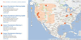
In addition to providing tools for developers, such as maps, databases or spreadsheets with application programming interface (API) - which can be integrated with third party code and data to create a myriad of custom applications, Google occasionally builds complete applications utilising those tools themselves. Public Alerts map is one such application.
Google Public Alerts is a project of the Google Crisis Response team, supported by Google.org. The key objective behind the project is to make it easy for people to find critical emergency information during a crisis through the online tools they use every day. This new platform for disseminating emergency messages, such as evacuation notices for hurricanes, and everyday alerts such as storm warnings and earthquake alerts initially focuses on the US but earthquake information covers the whole world. The data comes from US National Oceanic and Atmospheric Administration (NOAA), the National Weather Service, and the US Geological Survey (USGS).
Not sure what are the prospects for the take-up of this application since over the years many developers built much more advanced and informative versions, and which are very popular with public at the time of a crisis. Google created several of those themselves, eg bushfire information maps in Australia. Time will show how useful this will become…
Related Posts:
Disasters and maps
Perth bushfires
Japan hit by massive earthquakes
Another disaster looming for Oz

No comments:
Post a Comment